Helping design and engineering professionals discover, evaluate and specify technologies and processes that shorten the design cycle and enable success.


May 2026 Special Focus: Artificial Intelligence in Design and Simulation
In this Special Focus Issue, learn about the latest developments in the integration of artificial intelligence into engineering workflows.

Design & Simulation Software Guide 2025
In this Special Issue, Digital Engineering presents its second annual guide to design and simulation software vendors.
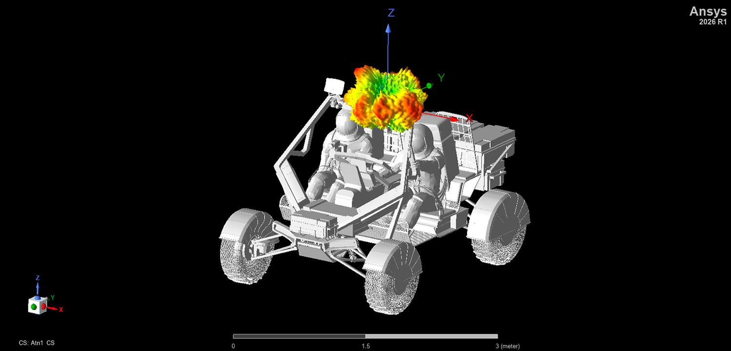
Shawn Carpenter, Program Director for 5G/6G & Space, Ansys, part of Synopsys, described his latest project as "lunar surface propagation modeling." Part of it was constructing a terrain model of the moon's surface -- a digital twin of the moon, in a manner of speaking.
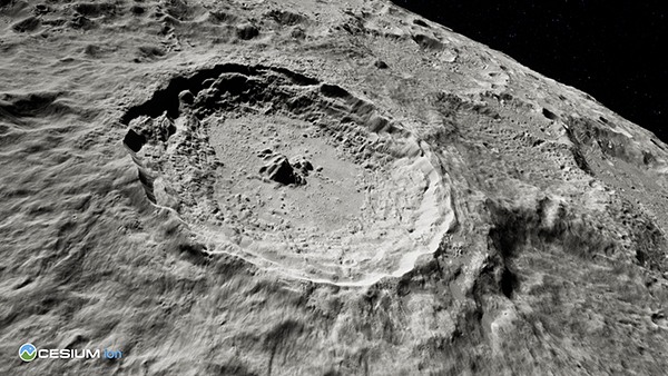
"There have been various models of the moon, probably since the space program came into existence, but they've been very crude," he said. Early versions were based on "what was telescopically measurable from the earth." Later models were based on what was captured by the synthetic aperture radar and cameras the crew brought with them. "Every mission to the moon helped acquire data to refine our understanding of that sphere," said Carpenter. "But they do not have the kind of resolution you might use for, say, planning telecommunication for a city."
The basis for the current model is a set of 3D tiles provided by Cesium, now part of Bentley Systems. The moon terrain model is part of the commercial subscription license of Cesium ion software, for creating and hosting 3D geospatial data in the cloud. Cesium also offers a community license of the software, free for personal use. The visualization client is free and open source. Alex Paulson, Director of Business Development, Cesium, described the virtual moon as "a selenography model," comprising not just 3D meshes but also latitudes and longitudes.
"Our solvers use the mesh information in these tiles to compute how the electromagnetic waves would spread across the moon," said Carpenter. "To model RF propagation between antennas, you could set up a link between our software and the data curated on Cesium's platform."
The Lunar 3GPP Project reveals how electromagnetic waves behave differently in the moon’s atmosphere compared to the earth’s. "On the moon, the electromagnetic waves are essentially propagating in a vacuum. So you have less loss and better reach. You don't experience oxygen absorption or water vapor absorption. But you do have spread loss. The signal behaves like dropping a pebble in a pool, and the lunar regolith has loss properties that, in some cases, are very high. It's statically charged materials that change propagation,” said Carpenter.
For simulation, material properties are the key to producing accurate results. "We took the tiles from Cesium and added dielectric properties: complex permittivity, complex permeability, and finite conductivity values, to describe the electromagnetic properties of the materials,” Carpenter said. Engineers relied on previous measurements obtained by the NASA scientists for these parameters.
Propagation simulation involves high-fidelity raytracing to study the wave paths and patterns. The combined use of raytracing and Ansys physics solvers benefitted tremendously from GPU acceleration, based on NVIDIA GPUs. "With the new simulation engine for NASA, we succeeded in accelerating the process by about one to three million times. It was that much faster," said Carpenter.
Through the propagation studies, "you may learn that you don't want to put a fuel tanker at a certain location, because it creates an electromagnetic barrier in the network," explained Carpenter.
Carpenter was confident that, by leveraging all the work that had been done in the commercial sector, engineers could find a way to establish a network that functions like a 4G, 5G, or 6G network on earth. "That means it could accommodate a number of high-definition video links simultaneously," he explained. "So astronauts could send text messages, photos, and live video feeds to each other."
To identify the best antenna placement and dead zones, telecommunication providers usually conduct site testing in advance with a test van. But "it's difficult to get that van to the moon ... so modeling and simulation at high fidelity is the primary way to mitigate these issues," said Carpenter.
Suppose an enterprising, futuristic manufacturing company plans to construct a production plant on the moon. “We have the base layer of terrain and imagery, so you can bring in BIM or CAD models that represent facilities that you might erect,” explained Paulson. “You can add metadata, for windows and doors and steel and concrete structures. These additions give context to the digital twin.”
The Envision Center at Purdue University has created an app called CollabXR, allowing researchers to visualize complex 3D data in an XR environment. Recently, the Center added support for Cesium for Unity, allowing users to visualize massive terrain datasets, including the moon tiles.

Synopsys, Inc. (Nasdaq: SNPS) is the Silicon to Software™ partner for innovative companies developing the electronic products and software applications we rely on every day. As the world's 15th largest software company, Synopsys has a long…
Kenneth Wong is Digital Engineering's resident blogger and senior editor. Email him at [email protected] or share your thoughts or suggestions at digitaleng.news/facebook.
Follow DEJoin over 90,000 engineering professionals who get fresh engineering news as soon as it is published.


About Us · Contact Us · Editorial Team · Advertising · Privacy Policy · Subscriber Services · © 2026 Digital Engineering 24/7 · Peerless Media