Helping design and engineering professionals discover, evaluate and specify technologies and processes that shorten the design cycle and enable success.

May 2026 Special Focus: Artificial Intelligence in Design and Simulation
In this Special Focus Issue, learn about the latest developments in the integration of artificial intelligence into engineering workflows.

April 2026 Special Focus Issue: Generative Design
In this Special Focus Issue, Digital Engineering takes a look at how generative design solutions can be used across different types of design problems and with a variety of manufacturing approaches to accelerate design space exploration, and…
The Cliffs of Moher are located on the coast of Ireland, in Country Clare, and are named after an ancient fortification that used to stand at the southern end of the cliffs. Along with being a major tourist attraction, the cliffs provide a home for a large number of nesting seabirds. The entire area was declared a Special Protection Area (SPA) for Birds under the EU Birds Directive in 1986.

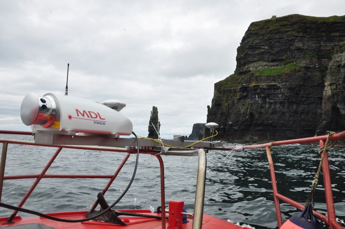
Plans for future development along the cliffs called for an environmental impact study. This was a problem without an obvious solution as the specific area to be studied is only accessible by boat, making a topological survey difficult. Coastway invited MDL to have a crack at the problem, and the company rose to the challenge by mounting a Dynascan 3D laser scanner to a fishing boat.
Both the portability and power of the Dynascan led to its selection. The device has a range of 500m and can produce data with an accuracy of +/-50. A GPS antenna was mounted alongside the Dynascan to provide positioning, and information was beamed in real time directly to a base camp set up over a known survey control point on the cliff top.
Nearly 2 kilometers of the Cliffs of Moher were scanned using this procedure, over the course of seven passes. The coverage had to be as complete as possible to ensure every detail of the cliff face and bays was captured. Topological data from the top of the cliffs was captured using a land-based vehicle, and was added to produce an overall picture of the cliffs. The entire collection process was completed in a single day.
All of the information was fed into a computer to create a point cloud, which is the basis of mesh modeling. Small, blank areas that were inaccessible to the boat because of shallow reefs were filled in using photos and Autodesk 123D. The final results produced a virtual image of the Cliffs of Moher that could not have been produced nearly as accurately with other kinds of technology.
Below you’ll find a couple of videos to compare and contrast. The first is the virtual reproduction of the cliffs by MDL, and the second is actual video of the cliffs.
Source: Renishaw

John Newman is a Digital Engineering contributor who focuses on 3D printing. Contact him via [email protected] and read his posts on Rapid Ready Technology.
Follow DEJoin over 90,000 engineering professionals who get fresh engineering news as soon as it is published.


About Us · Contact Us · Editorial Team · Advertising · Privacy Policy · Subscriber Services · © 2026 Digital Engineering 24/7 · Peerless Media